
Methodology for Landslide Susceptibility Assessment Along Linear Projects Study Case in the Water Supply Pipeline of Fredonia, Antioquia
Main Article Content
Keywords
Linear projects, SHALSTAB, conditional analysis, heuristic, TOBIA index, susceptibility, hazard
Abstract
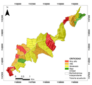
Landslides are characterized by their capacity to generate losses. In Colombia, a considerable percentage of those are associated with linear projects; between 2010-2011, 575 municipalities were affected by damage to the infrastructure of water supply network and sanitation. Considering this serious problem related to linear projects, the present work proposes the combination of heuristic, statistical and physical based methods to evaluate the susceptibility and hazard of landslides, under different scales of analysis. In addition to the construction of a critical unit map, using as the unit of analysis the Independent Morphodynamic Unit. The obtained model is validated using the success curves and the Area Under the Curve (AUC). The proposed methodology was implemented in the pipeline of the municipal aqueduct of the municipality of Fredonia in the Antioquia region. It was identified 6% of areas, both unstable and very high and high susceptibility; and 13% of areas corresponding to both cataclinal over dip and pure dip slope, as well as areas of very high and high susceptibility. The AUC for the conditional analysis and the criticality map showed a value of 0.81 and 0.73 indicating a very good fit and performance of the models.
Downloads
References
[2] A. K. Turner and R. L. Schuster, Landslides : investigation and mitigation. National Academy Press, 1996, no. 247. [Online]. Available: https://trid.trb.org/view.aspx?id=462499
[3] D. Petley, “Landslides and engineered slopes: protecting society through improved understanding.” Landslides and engineered slopes, vol. 1, pp. 3 – 13, 2012.
[4] Comision Economica para America Latina y el Caribe, “Valoracion de daños y perdidas: Ola Invernal en Colombia 2010- 2011,” Tech. Rep., 2012. [Online]. Available: http://repositorio.cepal.org/handle/11362/37958
[5] Ministerio de Vivienda Ciudad y Territorio, “Lineamientos de política de gestión del riesgo de desastres en la prestación de los servicios públicos de acueducto, alcantarillado y aseo.” p. 74, 2014.
[6] Ministerio de Vivienda Ciudad y Territorio and Unidad de Gestión de Riesgos y Desastres, “Lineamientos de Política de Gestión del Riesgo de Desastres en la prestación de los servicios públicos de acueducto, alcantarillado y aseo,” Bogotá, 2014. [Online]. Available: http:// repositorio.gestiondelriesgo.gov.co/handle/20.500.11762/20088http://www. minvivienda.gov.co/Documents/ViceministerioAgua/Gestióndelriesgo/ Lineamientosdepolíticadegestióndelriesgodedesastres.pdf
[7] R. Soeters and C. J. Van Westen, “Slope instability recognition, analysis, and zonation,” in Landslides: Investigation and Mitigation. Transportation Research Board Special Report, 1996, vol. 247, ch. 8, pp. 129–177.
[8] P. Aleottiand R. Chowdhury,“Land slide hazard assessment: summary review and new perspectives,” Bulletin of Engineering Geology and the Environment, vol. 58, no. 1, pp. 21–44, 1999.
[9] F. Guzzetti, A. Carrara, M. Cardinali, and P. Reichenbach, “Landslide hazard evaluation: a review of current techniques and their application in a multi-scale study, Central Italy,” Geomorphology, vol. 31, no. 1-4, pp. 181–216, dec 1999. [Online]. Available: http://linkinghub.elsevier.com/ retrieve/pii/S0169555X99000781
[10] J. Chacón, C. Irigaray, T. Fernández, and R. El Hamdouni, “Engineering geology maps: landslides and geographical information systems,” Bulletin of Engineering Geology and the Environment, vol. 65, no. 4, pp. 341–411, nov 2006. [Online]. Available: http://link.springer.com/10.1007/ s10064-006-0064-z
[11] R. Fell, J. Corominas, C. Bonnard, L. Cascini, E. Leroi, and W. Z. Savage, “Guidelines for landslide susceptibility, hazard and risk zoning for land use planning,” Engineering Geology, vol. 102, no. 3-4, pp. 85–98, 2008. [Online]. Available: http://dx.doi.org/10.1016/j.enggeo.2008.03.022
[12] F. Dai, C. Lee, and Y. Ngai, “Landslide risk assessment and management: an overview,” Engineering Geology, vol. 64, no. 1, pp. 65–87, apr 2002. [Online]. Available: http://www.sciencedirect.com/science/article/pii/ S001379520100093X
[13] J. Barredo, A. Benavides, J. Hervás, and C. J. van Westen, “Comparing heuristic landslide hazard assessment techniques using GIS in the Tirajana basin, Gran Canaria Island, Spain,” International Journal of Applied Earth Observation and Geoinformation, vol. 2, no. 1, pp. 9–23, jan 2000. [Online]. Available: http://www.sciencedirect.com/science/article/pii/ S0303243400850229
[14] L. Ayalew and H. Yagamishi, “The application of GIS-based logistic regression for landslide susceptibility mapping in the Kakuda-Yahiko Mountains, Central Japan,” Geomorphology, vol. 65, no. 1-2, pp. 15–31, feb 2005. [Online]. Available: http://www.sciencedirect.com/science/article/pii/ S0169555X04001631
[15] A. Carrara, “Uncertainty in Evaluating Landslide Hazard and Risk.” Springer, Dordrecht, 1993, pp. 101–109. [Online]. Available: https://link.springer.com/chapter/10.1007/978-94-015-8190-5_12
[16] T. W. van Asch, J.-P. Malet, L. P. van Beek, and D. Amitrano, “Techniques, issues and advances in numerical modelling of landslide hazard,” Bulletin de la Societe Geologique de France, vol. 178, no. 2, pp. 65–88, mar 2007. [Online]. Available: http://bsgf.geoscienceworld.org/lookup/doi/10. 2113/gssgfbull.178.2.65
[17] M. Casadei, W. E. Dietrich, and N. L. Miller, “Testing a model for predicting the timing and location of shallow landslide initiation in soil-mantled landscapes,” Earth Surface Processes and Landforms, vol. 28, no. 9, pp. 925– 950, aug 2003. [Online]. Available: http://doi.wiley.com/10.1002/esp.470
[18] C.-J. Chung, “Using likelihood ratio functions for modeling the conditional probability of occurrence of future landslides for risk assessment,” Computers & Geosciences, vol. 32, no. 8, pp. 1052–1068, oct 2006. [Online]. Available: http://www.sciencedirect.com/science/article/pii/S009830040600029X
[19] T. Chen, R. Niu, and X. Jia, “A comparison of information value and logistic regression models in landslide susceptibility mapping by using GIS,” Environmental Earth Sciences, vol. 75, no. 10, p. 867, may 2016. [Online]. Available: http://link.springer.com/10.1007/s12665-016-5317-y
[20] C. van Westen, “Application of geographic information systems to landslide hazard zonation,” 1993. [Online]. Available: https://repository.tudelft.nl/islandora/object/uuid: a59d2eca-ab58-41e6-91c9-01e4e090cf81?collection=research
[21] S. Lee, J. Choi, and K. Min, “Probabilistic landslide hazard mapping using GIS and remote sensing data at Boun, Korea,” International Journal of Remote Sensing, vol. 25, no. 11, pp. 2037–2052, jun 2004. [Online]. Available: http://www.tandfonline.com/doi/abs/10.1080/01431160310001618734
[22] C. F. Chung and A. Fabbri, “Representation of geoscience data for information integration,” J Non-Renewable Resour 2, vol. 2, pp. 122–139, 1993.
[23] R. B. Gorsevski, P.V.; Gessler, P.;Foltz, “Spatial Prediction of Landslide Hazard Using Discriminant Analysis and GIS,” 4th International Conference on Integrating GIS and Environmental Modeling (GIS/EM4); Problems, Prospects and Research Needs, 2000. [Online]. Available: https://www.researchgate.net/profile/Paul_Gessler/publication/ 209804015_Spatial_Prediction_of_Landslide_Hazard_Using_ Discriminant_Analysis_and_GIS/links/0deec523c91c7bcf80000000.pdf
[24] J. V. de Graff, E. Brabb, and A. King, “Landslide hazard assessment In: Primer on natural hazard management in integrated regional development planning. DRDE, General Secretariat, OAS,” Washington, D.C., Tech. Rep., 1991.
[25] A. Clerici, S. Perego, C. Tellini, and P. Vescovi, “A procedure for landslide susceptibility zonation by the conditional analysis method,” Geomorphology, vol. 48, no. 4, pp. 349–364, dec 2002. [Online]. Available: http://www.sciencedirect.com/science/article/pii/S0169555X0200079X
[26] A. Meijerink, “Data acquisition and data capture through terrain mapping unit.” ITC Journal, vol. 1, pp. 23–44, 1988.
[27] A. Erener and H. S. B. Düzgün, “Landslide susceptibility assessment: what are the effects of mapping unit and mapping method?” Environmental Earth Sciences, vol. 66, no. 3, pp. 859–877, jun 2012. [Online]. Available: http://link.springer.com/10.1007/s12665-011-1297-0
[28] A. Hansen, “Landslide hazard analysis,” in Slope Instability, D. E. Brunsden, D., Prior, Ed., New York, 1984, pp. 523–602.
[29] A. Carrara, “Multivariate models for landslide hazard evaluation,” Journal of the International Association for Mathematical Geology, vol. 15, no. 3, pp. 403–426, jun 1983. [Online]. Available: http: //link.springer.com/10.1007/BF01031290
[30] A. Hansen, C. A. M. Franks, and P. A. Kirk, “Application of GIS to Hazard Assessment, with particular reference to landslides in Hong Kong,” in Geographical Information Systems in Assessing Natural Hazards. Springer, Dordrecht, 1995, pp. 273–298. [Online]. Available: http://link.springer.com/10.1007/978-94-015-8404-3_14
[31] A. Carrara, M. Cardinali, R. Detti, F. Guzzetti, V. Pasqui, and P. Reichenbach, “GIS techniques and statistical models in evaluating landslide hazard,” Earth Surface Processes and Landforms, vol. 16, no. 5, pp. 427–445, aug 1991. [Online]. Available: http://doi.wiley.com/10.1002/ esp.3290160505
[32] G. F. Bonham-Carter, “Geographic Information Systems for Geoscientists: Modelling with GIS,” p. 398, 1994.
[33] A. Chica, Apuntes de geotecnia: cursos de geotecnia y prácticas geotécnicas., Facultad Nacional de Minas, Ed. Medellín, Colombia: Universidad Nacional de Colombia, 1989.
[34] D. R. Montgomery and W. E. Dietrich, “A physically based model for the topographic control on shallow landsliding,” Water Resources Research, vol. 30, no. 4, pp. 1153–1171, apr 1994. [Online]. Available: http://doi.wiley.com/10.1029/93WR02979
[35] R. K. Meentemeyer and A. Moody, “Automated mapping of conformity between topographic and geological surfaces,” Computers and Geosciences, vol. 26, no. 7, pp. 815–829, aug 2000. [Online]. Available: http: //www.sciencedirect.com/science/article/pii/S009830040000011X
[36] Operadores de Servicios E.S.P., “Informe de diagnóstico. Plan Maestro de Acueducto y Alcantarillado Urbano del Municipio de Fredonia: Información general del municipio.” Medellín, Colombia, pp. 1–69, 2005.
[37] B. Calle and H. González, “Geología y geoquímica de la plancha 166, Jericó,” vol. Informe N, p. 232, 1980.
[38] C. A. R. d. C. d. A. (CORANTIOQUIA), “Memoria geomorfológica de la plancha 166-Jericó,” in Mapa geomorfológico, de amenazas y de áreas degradadas de la jurisdicción de CORANTIOQUIA a escala 1:100.000: informe final, Medellín, Colombia, 2002.
[39] J. E. Henao Betancur, “Estratigrafía y petrografía de las areniscas de la secuencia quebrada La Naranjala - Municipio de Fredonia miembro inferior de la formación Amagá,” Ph.D. dissertation, Universidad EAFIT, 2012. [Online]. Available: https://repository.eafit.edu.co/handle/10784/735#. WelbA4iQy00
[40] J. F. Berrío, H. Caballero, M. E. Díaz, and M. V. Vélez, “Relación lluviaaguas subterráneas con deslizamientos en Fredonia, Antioquia, Colombia.” in XXI Congreso Latinoamericano de Hidráulica, Sao Pedro, oct 2004. [Online]. Available: http://www.bdigital.unal.edu.co/4398/
[41] F. Guzzetti, A. C. Mondini, M. Cardinali, F. Fiorucci, M. Santangelo, and K. T. Chang, “Land slide inventory maps: New tools for an old problem,” EarthScience Reviews, vol. 112, no. 1-2, pp. 42–66, apr 2012. [Online]. Available: http://www.sciencedirect.com/science/article/pii/S0012825212000128
[42] C.-J. F. Chung, A. G. Fabbri, and C. J. Van Westen, “Multivariate Regression Analysis for Landslide Hazard Zonation.” Springer, Dordrecht, 1995, pp. 107–133. [Online]. Available: http://link.springer.com/10.1007/ 978-94-015-8404-3_7
[43] P. Reichenbach, F. Guzzetti, and M. Cardinali, “Map of sites historically affected by landslides and floods, map at 1: 1 200 000 scale, CNR, Rome.” Rome, 1998.
[44] M. Santangelo, D. Gioia, M. Cardinali, F. Guzzetti, and M. Schiattarella, “Interplay between mass movement and fluvial network organization: An example from southern Apennines, Italy,” Geomorphology, vol. 188, pp. 54–67, apr 2013. [Online]. Available: http://www.sciencedirect.com/science/ article/pii/S0169555X12005570
45] M. Van Den Eeckhaut, N. Kerle, J. Poesen, and J. Hervás, “Object-oriented identification of forested landslides with derivatives of single pulse LiDAR data,” Geomorphology, vol. 173-174, pp. 30–42, nov 2012. [Online]. Available: http://www.sciencedirect.com/science/article/pii/S0169555X12002620
[46] A. Mondini and K.-t. Chang, “Combining spectral and geoenvironmental information for probabilistic event landslide mapping,” Geomorphology, vol. 213, pp. 183–189, may 2014. [Online]. Available: http://www.sciencedirect. com/science/article/pii/S0169555X14000324
[47] F. Ardizzone, M. Cardinali, A. Carrara, F. Guzzetti, and P. Reichenbach, “Impact of mapping errors on the reliability of landslide hazard maps,” Natural Hazards and Earth System Sciences, vol. 2, pp. 3–14, 2002. [Online]. Available: https://www.nat-hazards-earth-syst-sci.net/2/3/2002/ nhess-2-3-2002.pdf
[48] U. E. U. N. d. C. s. M. U. d. M. Área Metropolitana del Valle de Aburrá, Directrices y lineamientos para la elaboración de los estudios geológicos, geomorfológicos, hidrológicos, hidráulicos, hidrogeólogicos y geotécnicos para intervenciones en zonas de ladera, en el Valle de Aburrá, 2012. [Online]. Available: http://www.metropol.gov.co/Planeacion/ DocumentosAreaPlanificada/DirectricesAMVA.pdf
[49] J. V. De Graff, H. C. Romesburg, R. Ahmad, and J. P. McCalpin,“Producing landslide-susceptibility maps for regional planning in data-scarce regions,” Natural Hazards, vol. 64, no. 1, pp. 729–749, oct 2012. [Online]. Available: http://link.springer.com/10.1007/s11069-012-0267-5
[50] E. A. Castellanos Abella and C. J. Van Westen, “Qualitative landslide susceptibility assessment by multicriteria analysis: A case study from San Antonio del Sur, Guantánamo, Cuba,” Geomorphology, vol. 94, no. 3-4, pp. 453–466, feb 2008. [Online]. Available: http://www.sciencedirect.com/ science/article/pii/S0169555X07002784
[51] G. Sierra, J. C. Silva, and L. G. Correa, “Estratigrafía Secuencial de la Formación Amagá,” Boletín Ciencias de la Tierra, vol. 15, pp. 9 – 22, 2001.
[52] A. L. Little, “The Engineering Classification Of Residual Tropical Soils,” in 7th Int. Conf. Soil Mech & Foundation Engineering vol. 1, no. 0, 1969, pp. 1–10. [Online]. Available: https://trid.trb.org/view.aspx?id=121244
[53] R. V. Zuidam, Aerial photo-interpretation in terrain analysis and geomorphologic mapping. Smits Publishers, 1986.
[54] L. Ayalew and H. Yagamishi, “Slope failures in the Blue Nile basin, as seen from landscape evolution perspective,” Geomorphology, vol. 57, no. 1-2, pp. 95–116, jan 2004. [Online]. Available: http: //www.sciencedirect.com/science/article/pii/S0169555X03000850
[55] M. Komac, “A landslide susceptibility model using the Analytical Hierarchy Process method and multivariate statistics in perialpine Slovenia,” Geomorphology, vol. 74, no. 1-4, pp. 17–28, mar 2006. [Online]. Available: http://www.sciencedirect.com/science/article/pii/S0169555X05002072
[56] A. Yalcin, S. Reis, A. Aydinoglu, and T. Yomralioglu, “A GIS-based comparative study of frequency ratio, analytical hierarchy process, bivariate statistics and logistics regression methods for landslide susceptibility mapping in Trabzon, NE Turkey,” CATENA, vol. 85, no. 3, pp. 274–287, jun 2011. [Online]. Available: http://www.sciencedirect.com/science/article/ pii/S0341816211000233 185
[57] H. Y. Hussin, V. Zumpano, P. Reichenbach, S. Sterlacchini, M. Micu, C. van Westen, and D. Bäƒlteanu, “Different landslide sampling strategies in a grid-based bi-variate statistical susceptibility model,” Geomorphology, vol. 253, pp. 508–523, jan 2016. [Online]. Available: http://www.sciencedirect. com/science/article/pii/S0169555X15301951
[58] A. Clerici, S. Perego, C. Tellini, and P. Vescovi, “A GIS-based automated procedure for landslide susceptibility mapping by the Conditional Analysis method: the Baganza valley case study (Italian Northern Apennines),” Environmental Geology, vol. 50, no. 7, pp. 941–961, aug 2006. [Online]. Available: http://link.springer.com/10.1007/s00254-006-0264-7
[59] E. Aristizábal, E. García, and C. Martínez, “Susceptibility assessment of shallow landslides triggered by rainfall in tropical basins and mountainous terrains,” Natural Hazards, vol. 78, no. 1, pp. 621–634, aug 2015. [Online]. Available: http://link.springer.com/10.1007/s11069-015-1736-4
[60] E. M. O’Loughlin, “Prediction of Surface Saturation Zones in Natural Catchments by Topographic Analysis,” Water Resources Research, vol. 22, no. 5, pp. 794–804, may 1986. [Online]. Available: http://doi.wiley.com/10. 1029/WR022i005p00794
[61] J. Suárez, Deslizamientos: análisis geotécnico Vol. I., 2009. [Online]. Available: www.erosion.com.co
[62] A. Lizcano and M. C. Herrera, “Suelos derivados de cenizas volcánicas en colombia,” Rev. Int. de Desastres Naturales, Accidentes e Infraestructura Civil, vol. 6, no. 2, pp. 167–198, 2006. [Online]. Available: http: //www.pmrl.ce.gatech.edu/papers/Lizcano_2006a.pdf
[63] J. Salamanca and K. Sadeghian, “La densidad aparente y su relación con otras propiedades en suelos de la zona cafetera colombiana,” Cenicafé 56, vol. 4, pp. 381 – 397, 2005. [Online]. Available: http: //biblioteca.cenicafe.org/handle/10778/163
[64] L. Vallejo, M. Ferrer, L. Ortuño, and C. Oteo, Ingeniería Geológica, S. Pearson Educación, Ed., Madrid, 2002.
[65] A. Ortega and A. Serrano, “Índice de erosión pluvial y periodos de retorno para Fredonia, Jardín y Venecia,” Ph.D. dissertation, Universidad Nacional de Colombia, 1984.
[66] F. Guzzetti, P. Reichenbach, F. Ardizzone, M. Cardinali, and M. Galli, “Estimating the quality of landslide susceptibility models,” Geomorphology, vol. 81, no. 1-2, pp. 166–184, nov 2006. [Online]. Available: http: //www.sciencedirect.com/science/article/pii/S0169555X06001371
[67] C. van Westen, T. van Asch, and R. Soeters, “Landslide hazard and risk zonation-why is it still so difficult?” Bulletin of Engineering Geology and the Environment, vol. 65, no. 2, pp. 167–184, may 2006. [Online]. Available: http://link.springer.com/10.1007/s10064-005-0023-0
[68] J. S. Griffiths, A. E. Mather, and A. B. Hart, “Landslide susceptibility in the Río Aguas catchment, SE Spain,” Quarterly Journal of Engineering Geology and Hydrogeology, vol. 35, no. 1, pp. 9–17, feb 2002. [Online]. Available: http://qjegh.lyellcollection.org/cgi/doi/10.1144/qjegh.35.1.9
[69] D. Brunsden, “Geomorphological roulette for engineers and planners: some insights into an old game,” Quarterly Journal of Engineering Geology and Hydrogeology, vol. 35, no. 2, pp. 101–142, may 2002. [Online]. Available: http://qjegh.lyellcollection.org/cgi/doi/10.1144/1470-92362001-40
[70] A. Ozdemir and T. Altural, “A comparative study of frequency ratio, weights of evidence and logistic regression methods for landslide susceptibility mapping: Sultan mountains, SW Turkey,” Journal of Asian Earth Sciences, vol. 64, pp. 180–197, mar 2013. [Online]. Available: http://www.sciencedirect.com/science/article/pii/S1367912012005585
Article Sidebar
Article Details
Authors who publish with this journal agree to the following terms:
- Authors retain copyright and grant the journal right of first publication with the work simultaneously licensed under a Creative Commons Attribution License that allows others to share the work with an acknowledgement of the work's authorship and initial publication in this journal.
- Authors are able to enter into separate, additional contractual arrangements for the non-exclusive distribution of the journal's published version of the work (e.g., post it to an institutional repository or publish it in a book), with an acknowledgement of its initial publication in this journal.
- Authors are permitted and encouraged to post their work online (e.g., in institutional repositories or on their website) prior to and during the submission process, as it can lead to productive exchanges, as well as earlier and greater citation of published work (See The Effect of Open Access).