
Correlación de variables morfométricas para deslizamientos en la cuenca del río Combeima, Colombia
Main Article Content
Keywords
Deslizamientos, Morfometría, Sensoramiento remoto, SIG, río Combeima
Resumen
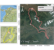
En la cuenca del río Combeima (Tolima, Colombia), se desarrolló un estudio con el fin de estimar las variables morfométricas de los deslizamientos encontrados y obtener posibles correlaciones estadísticas entre ellas. Para obtener las características morfométricas de los deslizamientos se empleó una base de datos con deslizamientos históricos, una imagen RapidEye del año 2010 y un ortofotomosaico del año 2009, en donde se identificaron visualmente los deslizamientos. Las características morfométricas fueron definidas a través de un sistema de información geográfico y se realizaron análisis bivariados entre las variables morfométricas para establecer sus correlaciones. Los resultados permitieron identificar 121 deslizamientos, con área promedio de 1,974.97 m2 y distribución tipo Birnbaum-Saunders. Se encontró que la variable morfométrica área de deslizamiento se correlaciona con la longitud total (R2=0.9414), la longitud de línea central (R2=0.9368) y el ancho de la superficie de ruptura (R2=0.8915) de este, y podría usarse para inferir el volumen de la masa involucrada en el evento y sus efectos potenciales. Este resultado permitiría usar el área de los deslizamientos como apoyo en la toma de decisión en la planificación del territorio en la cuenca del río Combeima.
Descargas
Referencias
[1] L. Highland and P. Bobrowsky, Manual de derrumbes: Una guía para entender todo sobre los derrumbes. Reston, Virginia: Circular 1325 del Sistema Geológico de los EUA, 2008.
[2] M. Acar, M. T. Ozludemir, S. Erol, R. N. Celik, and T. Ayan, “Kinematic landslide monitoring with Kalman filtering,” Natural Hazards and Earth System Science, vol. 8, no. 2, pp. 213–221, 2008. https://doi.org/10.5194/nhess-8-213-2008
[3] J. Barredo, A. Benavides, J. Hervás, and C. J. Van Westen, “Comparing heuristic landslide hazard assessment techniques using GIS in the Tirajana basin, Gran Canaria Island, Spain,” International Journal of Applied Earth Observation and Geoinformation, vol. 2, no. 1, pp. 9–23, 2000. https://doi.org/10.1016/S0303-2434(00)85022-9
[4] R. Behling, S. Roessner, H. Kaufmann, and B. Kleinschmit, “Automated spatiotemporal landslide mapping over large areas using rapideye time series data,” Remote Sensing, 2014. https://doi.org/10.3390/rs6098026
[5] R. copons llorens and A. Masquef, “Movimientos de ladera,” Enseñanza de las Ciencias de la Tierra, vol. 17, no. 3, pp. 284–294, 01 2009
[6] D. Cruden and D. Varnes, “Landslide types and processes,” in Landslides: investigation and mitigation, 247th ed., K. Turner and R. Schuster, Eds. Transport Research Board Special Report, 1996, ch. 3, pp. 36–75.
[7] T. Hattanji and H. Moriwaki, “Morphometric analysis of relic landslides using detailed landslide distribution maps: Implications for forecasting travel distance of future landslides,” Geomorphology, vol. 103, no. 3, pp. 447–454, 2009. https://doi.org/10.1016/j.geomorph.2008.07.009
[8] Q. Lin, Z. Zou, L. Lin, and Y.Wang, “Combining Spectral and Morphometric Properties of Landslides for Separating Individual Landslides Based on Object-Oriented Method,” Advancing Culture of Living with Landslides, vol. 5, pp. 1–557, 2017. https://doi.org/10.1007/978-3-319-53483-1
[9] F. Guzzetti, F. Ardizzone, M. Cardinali, M. Galli, P. Reichenbach, and M. Rossi, “Distribution of landslides in the Upper Tiber River basin, central Italy,” Geomorphology, vol. 96, no. 1-2, pp. 105–122, 2008. https://doi.org/10.1016/j.geomorph.2007.07.015
[10] M. Moine, a. Puissant, and J. Malet, “Detection of landslides from aerial and satellite images with a semi-automatic method. Application to the Barcelonnette basin (Alpes-de-Hautes-Provence, France),” Proceedings of the landslide processes conference–A tribute to Dr. Theo van Asch, pp. 63–68, 2009. http://halshs.archives-ouvertes.fr/halshs-00467545/
[11] F. Rapisarda, “Morphometric and landsliding analyses in Chain domain: The Roccella basin, NE Sicily, Italy,” Environmental Geology, vol. 58, no. 7, pp. 1407–1417, 2008. https://doi.org/10.1007/s00254-008-1643-z
[12] D. Petrea, . Bilasco, S. Rosca, I. Vescan, and I. Fodorean, “The determination of the Landslide occurence probability by spatial analysis of the Land Morphometric ...” Carpathian Journal of Earth and Environmental Sciences, vol. 9, no. May, pp. 91–102, 2014.
[13] R. Fontes, W. Portela, O. De Carvalho, D. Montgomery, R. Troncoso, H. Greenberg, M. Cataldi, and P. Coutinho, “Determination of Areas Susceptible to Landsliding Using Spatial Patterns of Rainfall from Tropical Rainfall Measuring Mission Data , Rio de Janeiro , Brazil,” International journal of Geo-Information, vol. 6, no. 289, p. 16, 2017. https://doi.org/10.3390/ijgi6100289
[14] M. Calista, E. Miccadei, A. Pasculli, T. Piacentini, M. Sciarra, and N. Sciarra, “First results of morphometric analysis, multitemporal geomorphological investigation and numerical modeling of the Montebello sul Sangro landslide (Abruzzo, Central Italy),” Rendiconti Online Societa Geologica Italiana, vol. 35, no. January 2016, pp. 307–310, 2015. https://doi.org/10.3301/ROL.2015.127
[15] J. P. Carvalho, F. Dourado, and F. Ferreira, “Morphometric analysis of landslide in the Mountain Region of the State of Rio de Janeiro in Brazi : the case study of D ’ anta s watershed,” Geophysical Research Abstracts, vol. 15, 2013.
[16] M. Santangelo, D. Gioia, M. Cardinali, F. Guzzetti, and M. Schiattarella, “Landslide inventory map of the upper Sinni River valley, Southern Italy,” Journal of Maps, vol. 11, no. 3, pp. 444–453, 2015. https://doi.org/10.1080/17445647.2014.949313
[17] R. H. Guthrie and S. G. Evans, “Magnitude and frequency of landslides triggered by a storm event, Loughborough Inlet, British Columbia.” pp. 36–50, 2004. https://doi.org/10.1561/2200000016
[18] F. Brardinoni and M. Church, “Representing the landslide magnitudefrequency relation: Capilano River basin, British Columbia,” Earth Surface Processes and Landforms, vol. 29, no. 1, pp. 115–124, 2004. https://doi.org/10.1002/esp.1029
[19] X. G. Wang, W. Wang, D. Huang, B. Yong, and X. Chen, “Modifying SEBAL model based on the trapezoidal relationship between land surface temperature and vegetation index for actual evapotranspiration estimation,” Remote Sensing, vol. 6, no. 7, pp. 5909–5937, 2014. https://doi.org/10.3390/rs60x000x
[20] R. Guimarães, W. Machado, O. de Carvalho, D. Montgomery, R. Gomes, H. Greenberg, M. Cataldi, and P. Mendonça, “Determination of Areas Susceptible to Landsliding Using Spatial Patterns of Rainfall from Tropical Rainfall Measuring Mission Data, Rio de Janeiro, Brazil,” ISPRS International Journal of Geo-Information, vol. 6, no. 10, p. 289, 2017. https://doi.org/10.3390/ijgi6100289
[21] F. Guzzetti, B. D. Malamud, D. L. Turcotte, and P. Reichenbach, “Power-law correlations of landslide areas in central Italy,” vol. 195, pp. 169–183, 2002. https://doi.org/10.1016/S0012-821X(01)00589-1
[22] E. Muñoz and H. Martínez, “Propiedades Estadísticas de un Inventario de Deslizamientos en la Ciudad de Medellín, Colombia.” 10 Simposio Internacional de Estructuras, Geotecnia y Materiales de Construcción, no. February, p. 9, 2013.
[23] Servicio Geológico Colombiano, “Sistema de Información de Movimientos en Masa (SIMMA),” p. 1, 2018. http://simma.sgc.gov.co/
[24] C. Corporaciíon Autonoma Regional del Tolima, C. Corporación Colombiana de Investigación Agropecuaria, and S. Servicio Nacional de Aprendizaje, “Plan de ordenación y manejo de la cuenca mayor del río coello,” in Fase Ii. Diagnostico Río Coello, 1st ed., Ibague, 2006, pp. 55–69.
[25] J. Leal and L. A. Lozano, “Niveles de fragilidad potencial para erosión y deslizamiento en los suelos del municipio de Niveles de fragilidad potencial para la erosión y el deslizamiento en los suelos del municipio de Ibagué.” Revista de Investigación Agraria y Ambiental RIAA, vol. 3, no. 1, pp. 67–76, 2012. http://dialnet.unirioja.es/servlet/articulo?codigo=4227172
[26] A. Y. Hernández, “Caracterización y análisis de la amenaza y la vulnerabilidad física por taludes inestables en la microcuenca de la Quebrada Cay, Ibagué, departamento del Tolima,” p. 260, 2013. 149, 161
[27] J. Leal, “Incidencia del cambio de las coberturas vegetales en la distribución espacial de los deslizamientos en la cuenca del río Combeima (Ibagué-Tolima, Colombia),” Tesis de Maestría, Universidad del Tolima, 2015. https://doi.org/10.13140/RG.2.2.29189.86247
[28] H. Vergara and M. Moreno, “Estudio geológico geotécnico de la cuenca del río Combeima,” 1992.
[29] Alcaldía de Ibagué y Corporación Autónoma Regional del Tolima., “Estudio de amenazas naturales , vulnerabilidad y escenarios de riesgo en los centros poblados de Villa Restrepo, Llanitos, Juntas , Pastales , Pico de Oro, Bocatoma Combeima y Cay por flujos torrenciales en las microcuencas del río Combeima.” Ibagué, 2012. https://www.cortolima.gov.co/contenido/estudio-riesgo-ca-n-gu-ajuste-pot-sector
[30] J. Leal, U. Pérez, and N. Ortiz, “Distribución espacial y temporal de deslizamientos (1999-2015) en la cuenca del río Combeima, Colombia,” Revista Geográfica Venezolana, vol. 59, no. 2, pp. 346–365, 2018. http://www.saber.ula.ve/handle/123456789/45286
[31] U. Pérez and J. Bosque, “Transiciones de la cobertura y uso de la tierra en el período 1991 - 2005 en la cuenca del Río Combeima, Colombia.” Serie Geográfica, vol. 14, no. 1, pp. 163–178, 2008.
[32] J. Muñoz Ramos, A. Guío Duque, H. Andrade Castañeda, M. Segura Madrigal, M. Barrios Peña, S. Losada Prado, and M. Gómez Martínez, Esquema de pago por servicios ambientales para la cuenca alta del río Combeima en el Municipio de Ibagué ( Tolima , Colombia )., 1st ed., Ibagé-Tolima, 2013.
[33] Instituto Geográfico Agustín Codazzi., “Imagen Rapideye 0403012000000230.” Bogota D.C, 2010. http://www.bni.gov.co/portal/public/classic/Busqueda?faces-redirect=true
[34] Instituto Geográfico Agustín Codazzi., “Banco Nacional de Imágenes. 2018,” Bogota D.C, 2018. http://www.bni.gov.co/portal/public/classic/home
[35] A. P. JAXA / METI, “ASF Data Search,” 2010. https://search.asf.alaska.edu
[36] F. Mantovani, R. Soeters, and C. Van Westen, “Remote sensing techniques for landslide studies and hazard zonation in Europe,” Geomorphology, vol. 15, no. 3-4, pp. 213–225, 1996. https://doi.org/10.1016/0169-555X(95)00071-C
[37] T. Fernández, J. Jiménez, J. L. Pérez, J. Delgado, F. J. Cardenal, C. Chacón, and J. Irigaray, “Identificación de escarpes de movimientos de ladera mediante técnicas de teledetección,” Tecnologías de la Información Geográfica: La información geográfica al servicio de los ciudadanos., pp. 818–829, 2010. https://idus.us.es/bitstream/handle/11441/66631/FERNANDEZ.pdf?sequence=1&isAllowed=y
[38] J. Rouse, R. Hass, J. Schell, and D. Deering, “Monitoring vegetation systems in the great plains with ERTS,” in Third Earth Resources Technology Satellite (ERTS) symposium, vol. 1. NASA SP-351, 1973, pp. 309–317. https://ntrs.nasa.gov/archive/nasa/casi.ntrs.nasa.gov/19740022614.pdf
[39] T. Zieher, F. Perzl, M. Rutzinger, and G. Markart, “A multiannual landslide inventory for the assessment of shallow landslide susceptibility” Two test cases in Vorarlberg , Austria,” no. April, 2016. https://doi.org/10.1016/j.geomorph.2016.02.008
[40] Generalitad Valenciana, “gvSIG,” Valencia, España, 2018. http://www.gvsig.com/
[41] B. Duruturk, N. Demir, I. Koseoglu, U. B. Onal, and M. Ercanoglu, “Gis-Based Determination of Landslide Properties in Regional Scale: Karabuk Province (NW Turkey),” Annals of Valahia University of Targoviste, Geographical Series, vol. 17, no. 1, pp. 37–46, 2017. https://doi.org/10.1515/avutgs-2017-0004
[42] H. Gichenje and S. Godinho, “Establishing a land degradation neutrality national baseline through trend analysis of gimms ndvi time-series,” Land Degradation & Development, vol. 29, no. 9, pp. 2985–2997, 2018. https://doi.org/10.1002/ldr.3067
[43] T. Le and S. Kawagoe, “Landslide detection analysis in north vietnam base on satellite images and digital geographical information - landsat 8 satellite and historical data approaches,” vol. 73, no. 5, pp. I_239–I_249, 2017. https://doi.org/10.2208/jscejer.73.I_239
[44] L. Metz and A. Bear, “Landslide susceptibility mapping : a remote sensing based approach using QGIS 2.2 (Valmiera) : technical manual. Canberra Geoscience Australia,” Geoscience Australia, 2014.
[45] J. Kim and K. Kim, “Analysis of 2016 Minamiaso landslides using remote sensing and geographic information system,” Journal of Applied Remote Sensing, vol. 12, 2018.
[46] A. Stumpf, D. Michéa, and J. P. Malet, “Improved co-registration of Sentinel- 2 and Landsat-8 imagery for Earth surface motion measurements,” Remote Sensing, vol. 10, no. 2, pp. 1–20, 2018. https://doi.org/10.3390/rs10020160
[47] B. Yu, F. Chen, and S. Muhammad, “Analysis of satellite-derived landslide at Central Nepal from 2011 to 2016,” Environ Earth Sci, 2018. https://doi.org/10.1007/s12665-018-7516-1
[48] R. Soeters and C. Van Westen, “Slope instability recognition, analysis, and zonation,” Landslides: Investigation and Mitigation, pp. 129–177, 1996.
[49] Y. Huang, M. Yu, Q. Xu, K. Sawada, S. Moriguchi, A. Yashima, C. Liu, and L. Xue, “InSAR-derived digital elevation models for terrain change analysis of earthquake-triggered flow-like landslides based on ALOS/PALSAR imagery,” Environmental Earth Sciences, vol. 73, no. 11, pp. 7661–7668, 2015. https://doi.org/10.1007/s12665-014-3939-5
[50] J. E. Nichol, A. Shaker, and M. S. Wong, “Application of highresolution stereo satellite images to detailed landslide hazard assessment,” Geomorphology, vol. 76, no. 1-2, pp. 68–75, 2006. https://doi.org/10.1016/j.geomorph.2005.10.001
[51] J. Nichol and M. S. Wong, “Satellite remote sensing for detailed landslide inventories using change detection and image fusion,” International Journal of Remote Sensing, vol. 26, no. 10, pp. 1913–1926, 2005.
[52] I. Marchesini, F. Ardizzone, M. Alvioli, M. Rossi, and F. Guzzetti, “Non-susceptible landslide areas in Italy and in the Mediterranean region,” Natural Hazards and Earth System Sciences, vol. 14, pp. 2215–2231, 2014. https://doi.org/10.5194/nhess-14-2215-2014
[53] A. Mayr, M. Rutzinger, and C. Geitner, “Multitemporal analysis of objects in 3D point clouds for landslide monitoring,” International Archives of the Photogrammetry, Remote Sensing and Spatial Information Sciences - ISPRS Archives, vol. 42, no. 2, pp. 691–697, 2018. https://doi.org/10.5194/isprs-archives-XLII-2-691-2018
[54] B. D. Malamud, D. L. Turcotte, F. Guzzetti, and P. Reichenbach, “Landslide inventories and their statistical properties,” Earth Surface Processes and Landforms, vol. 29, no. 6, pp. 687–711, 2004. https://doi.org/10.1002/esp.1064
[55] J. D. Pelletier, “Scale-invariance of soil moisture variability and its implications for the frequency-size distribution of landslides,” vol. 48, 1997. https://doi.org/10.1016/S0013-7952(97)00041-0
[56] N. Hovius and C. Stark, “The characterization of landslide size distributions,” Geophysical research letters, vol. 28, no. 6, pp. 1091–1094, 2001.
[57] J. Corominas, “The angle of reach as a mobility index for small and large landslides,” Canadian Geotechnical Journal, 1996. https://doi.org/10.1139/t96-005
[58] M. Jakob, D. Stein, and M. Ulmi, “Vulnerability of buildings to debris flow impact,” Natural Hazards, 2012. https://doi.org/10.1007/s11069-011-0007-2
[59] J. von Ruette, P. Lehmann, and D. Or, “Linking rainfall-induced landslides with predictions of debris flow runout distances,” Landslides, 2016. https://doi.org/10.1007/s10346-015-0621-2
[60] J. Michel, C. Dario, D. Marc-Henri, O. Thierry, P. Ivanna Marina, and R. Bejamin, “A review of methods used to estimate initial landslide failure surface depths and volumes,” Engineering Geology, 2020. https://doi.org/10.1016/j.enggeo.2020.105478
[61] M. H. Vahidnia, A. A. Alesheikh, A. Alimohammadi, and F. Hosseinali, “Landslide Hazard Zonation Using Quantitative Methods in GIS,” vol. 7, no. 3, pp. 176–189, 2009.
[62] F. Ardizzone, M. Cardinali, A. Carrara, F. Guzzetti, and P. Reichenbach, “Impact of mapping errors on the reliability of landslide hazard maps,” Natural Hazards and Earth System Sciences, p. 12, 2002. https://www.nat-hazards-earth-syst-sci.net/2/3/2002/nhess-2-3-2002.pdf
[63] P. Reichenbach, M. Galli, M. Cardinali, F. Guzzetti, and F. Ardizzone, Geomorphological Mapping to Assess Landslide Risk: Concepts, Methods and Applications in the Umbria Region of Central Italy, 2012
Article Sidebar
Article Details
Juan Cuevas-González, Universidad del Tolima
Ingeniero forestal. Grupo de Investigación en Producción Ecoamigable de Cultivos Tropicales. Universidad del Tolima.
Julián Leal-Villamíl, Universidad del Tolima
Grupo Interdisciplinario de Investigación en Fruticultura Tropical. Doctor en Planificación y Manejo Ambiental de Cuencas Hidrográficas. Universidad del Tolima. Ver perfil en Google Académico
Jader Muñoz-Ramos, Universidad del Tolima
Doctor en Ciencias Agrícolas. Profesor de la Facultad de Ingeniería Civil. Grupo de Investigación en Producción Ecoamigable de Cultivos Tropicales. Universidad del Tolima. Ver perfil en Google Académico
Los autores que publican en esta revista están de acuerdo con los siguientes términos:
- Los autores conservan los derechos de autor y garantizan a la revista el derecho de ser la primera publicación del trabajo al igual que licenciado bajo una Creative Commons Attribution License que permite a otros compartir el trabajo con un reconocimiento de la autoría del trabajo y la publicación inicial en esta revista.
- Los autores pueden establecer por separado acuerdos adicionales para la distribución no exclusiva de la versión de la obra publicada en la revista (por ejemplo, situarlo en un repositorio institucional o publicarlo en un libro), con un reconocimiento de su publicación inicial en esta revista.
- Se permite y se anima a los autores a difundir sus trabajos electrónicamente (por ejemplo, en repositorios institucionales o en su propio sitio web) antes y durante el proceso de envío, ya que puede dar lugar a intercambios productivos, así como a una citación más temprana y mayor de los trabajos publicados (Véase The Effect of Open Access) (en inglés).