
Adquisición y evaluación de datos geométricos de macizos rocosos a partir de imágenes tridimensionales para su uso en análisis geotécnicos
Main Article Content
Keywords
Análisis de imágenes tridimensionales, macizo rocoso, caracterización de discontinuidades, detección remota, mapeo geológico, Colombia
Resumen
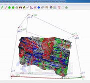
En este artículo, se evalúa la aplicación de una herramienta de adquisición remota para el muestreo y la medición de propiedades de las discontinuidades en macizos rocosos, basado en la toma e interpretación de imágenes tridimensionales. Metodológicamente, se integra un amplio plan experimental tanto en campo como en laboratorio computacional, para recopilar datos estructurales tales como la orientación, la persistencia y espaciamiento de discontinuidades presentes en un macizo rocoso tomado como caso de estudio. Paralelamente, se llevó a cabo un intenso trabajo de toma de datos en campo por metodologías convencionales de brújula y cinta, con fines comparativos y de validación estadística. Los resultados obtenidos permiten establecer las ventajas del uso de técnicas no convencionales, en términos de calidad y cantidad de información, así como de eficiencia en términos del tiempo requerido para el levantamiento de información en campo. Mediante el análisis semiautomático de imágenes tridimensionales se logró el mapeo geológico y la caracterización de discontinuidades para fines geotécnicos, constituyéndose en una herramienta poderosa con gran potencial de uso en proyectos viales y mineros en el medio colombiano.
Descargas
Referencias
[2] G. Baecher and N. A. Lanney, “Trace length biases in joint surveys,” in In 19th US Symposium on Rock Mechanics (USRMS), 1978, pp. 56–65. [Online]. Available: https://www.onepetro.org/conference-paper/ARMA-78-0080
[3] S. Priest and J. Hudson, “Discontinuity spacings in rock,” International Journal of Rock Mechanics and Mining Sciences & Geomechanics Abstracts, vol. 13, no. 5, pp. 135–148, may 1976. [Online]. Available: https://doi.org/10.1016/0148-9062(76)90818-4
[4] S. D. Priest and J. A. Hudson, “Estimation of discontinuity spacing and trace length using scanline surveys,” International Journal of Rock Mechanics and Mining Sciences & Geomechanics Abstracts, vol. 18, no. 3, pp. 183–197, jun 1981. [Online]. Available: https://doi.org/10.1016/0148-9062(81)90973-6
[5] V. Ewan and G. West, “Reproducibility of joint orientation measurements in rock,” Transport and Road Research Laboratory (TRRL), 1981. [Online]. Available: https://trid.trb.org/view/179882
[6] A. Gaich, M. Poetsch, and W. Schubert, “Acquisition and assessment of geometric rock mass features by true 3D images,” in The 41st U.S. Symposium on Rock Mechanics. Golden, Colorado: American Rock Mechanics Association, jan 2006. [Online]. Available: https://www.onepetro. org/conference-paper/ARMA-06-1051
[7] J. B. Campbell and R. H. Wynne, Introduction to remote sensing. Guilford Press, 2011. [Online]. Available: https://www.guilford.com/books/Introduction-to-Remote-Sensing/ Campbell-Wynne/9781609181765/reviews
[8] Á. N. Bhreasail, O. Pritchard, S. Carluccio, J. Manning, T. Daly, A. Merritt, and J. Codd, “Remote Sensing for Proactive Geotechnical Asset Management on England’s Strategic Road Network,” Infrastructure Asset Management, pp. 1–40, jun 2018. [Online]. Available: https: //doi.org/10.1680/jinam.17.00025
[9] F. Cigna, S. Bianchini, and N. Casagli, “How to assess landslide activity and intensity with Persistent Scatterer Interferometry (PSI): the PSI-based matrix approach,” Landslides, vol. 10, no. 3, pp. 267–283, jun 2013. [Online]. Available: https://doi.org/10.1007/s10346-012-0335-7
[10] J. Martinez, F. Buill, and J. Bartoll, “Utilización de técnicas láser escáner y de fotogrametría terrestre para el estudio de desprendimientos de rocas: el caso de la zona de más riesgo del tren cremallera,” Mapping, vol. 103, pp. 26–33, 2005. [Online]. Available: https://dialnet.unirioja.es/servlet/articulo? codigo=1211877
[11] A. Bell, J. McKinley, D. Hughes, M. Hendry, and A. Macciotta, “Spatial and temporal analyses using Terrestrial LiDAR for monitoring of landslides to determine key slope instability thresholds: Examples from Northern Ireland and Canada,” in 6th Canadian GeoHazards Conference—GeoHazards 6, 2014, pp. 15–18.
[12] T. G. Carter, A. Begin, P. Dittrich, C. Evans, J. Byron, P. Rico, J. L. Carvalho, N. Solis, R. Gillinder, L. F. Brewster, R. Arthur, D. Williamson, and R. Murdoch, “Innovative use of GIS and drone photogrammetry for cliff stability modelling,” Proceedings of the Institution of Civil Engineers - Maritime Engineering, vol. 171, no. 3, pp. 89–97, sep 2018. [Online]. Available: https://doi.org/10.1680/jmaen.2018.17
[13] F. Cigna, V. Banks, A. Donald, S. Donohue, C. Graham, D. Hughes, J. McKinley, K. Parker, F. Cigna, V. J. Banks, A. W. Donald, S. Donohue, C. Graham, D. Hughes, J. M. McKinley, and K. Parker, “Mapping Ground Instability in Areas of Geotechnical Infrastructure Using Satellite InSAR and Small UAV Surveying: A Case Study in Northern Ireland,” Geosciences, vol. 7, no. 3, p. 51, jul 2017. [Online]. Available: https://doi.org/10.3390/geosciences7030051
[14] J. Park, M. Bates, Y. S. Jeong, K. M. Kim, and J. Kemeny, “Creating a Digital Outcrop Model by Using Hyper-Spectrometry and Terrestrial LiDAR,” in 50th U.S. Rock Mechanics/Geomechanics Symposium. American Rock Mechanics Association, jun 2016, pp. 26–29. [Online]. Available: https://www.onepetro.org/conference-paper/ARMA-2016-507
[15] J. Chen, K. Li, K.-J. Chang, G. Sofia, and P. Tarolli, “Open-pit mining geomorphic feature characterisation,” International Journal of Applied Earth Observation and Geoinformation, vol. 42, pp. 76–86, oct 2015. [Online]. Available: https://doi.org/10.1016/J.JAG.2015.05.001
[16] R. Salvini, M. Francioni, S. Riccucci, F. Bonciani, and I. Callegari, “Photogrammetry and laser scanning for analyzing slope stability and rock fall runout along the Domodossola–Iselle railway, the Italian Alps,” Geomorphology, vol. 185, pp. 110–122, mar 2013. [Online]. Available: https://doi.org/10.1016/J.GEOMORPH.2012.12.020
[17] A. Riquelme, M. Cano, R. Tomás, and A. Abellán, “Identification of rock slope discontinuity sets from laser scanner and photogrammetric point clouds: A comparative analysis,” in Symposium of the International Society for Rock Mechanics, EUROCK 2017., Ostrava-Poruba, Czech Republic, 2017, pp. 838–845. [Online]. Available: http://rua.ua.es/dspace/handle/10045/67538
[18] G. Firpo, R. Salvini, M. Francioni, and P. Ranjith, “Use of Digital Terrestrial Photogrammetry in rocky slope stability analysis by Distinct Elements Numerical Methods,” International Journal of Rock Mechanics and Mining Sciences, vol. 48, no. 7, pp. 1045–1054, oct 2011. [Online]. Available: https://doi.org/10.1016/J.IJRMMS.2011.07.007
[19] H. Zhu, X. Li, and X. Zhuang, “Recent advances of digitization in rock mechanics and rock engineering,” Journal of Rock Mechanics and Geotechnical Engineering, vol. 3, no. 3, pp. 220–233, sep 2011. [Online]. Available: https://doi.org/10.3724/SP.J.1235.2011.00220
[20] V. Bonilla-Sierra, L. Scholtès, F. V. Donzé, and M. K. Elmouttie, “Rock slope stability analysis using photogrammetric data and DFN–DEM modelling,” Acta Geotechnica, vol. 10, no. 4, pp. 497–511, aug 2015. [Online]. Available: https://doi.org/10.1007/s11440-015-0374-z
[21] V. Bonilla-Sierra, M. Elmouttie, F.-V. Donzé, and L. Scholtès, “Composite wedge failure using photogrammetric measurements and DFN-DEM modelling,” Journal of Rock Mechanics and Geotechnical Engineering, vol. 9, no. 1, pp. 41–53, feb 2017. [Online]. Available: https://doi.org/10.1016/J. JRMGE.2016.08.005
[22] D. Tannant, “Review of Photogrammetry-Based Techniques for Characterization and Hazard Assessment of Rock Faces,” International journal of geohazards and environment, vol. 1, no. 2, pp. 76–87, jul 2015. [Online]. Available: https://doi.org/10.15273/ijge.2015.02.009
[23] W. Gates and W. Haneberg, “Comparison of Standard Structural Mapping Results to 3-D Photogrammetric Model Results: Boundary Transformer Banks Rockfall Mitigation Project, Metaline Falls, Washington,” in 46th US Rock Mechanics Geomechanics Symposium. American Rock Mechanics Association, jan 2012, pp. 24–27. [Online]. Available: https: //www.onepetro.org/conference-paper/ARMA-2012-368
[24] H. D. Preuss, “Numerisch-photogrammetrische Kluftmessung.” Springer, Vienna, 1974, pp. 5–15. [Online]. Available: https://doi.org/10.1007/ 978-3-7091-8372-4_3
[25] T. Hagan, “A case for terrestrial photogrammetry in deep-mine rock structure studies,” International Journal of Rock Mechanics and Mining Sciences & Geomechanics Abstracts, vol. 17, no. 4, pp. 191–198, aug 1980. [Online]. Available: https://doi.org/10.1016/0148-9062(80)91085-2
[26] C. Tsoutrelis, G. Exadaktylos, and A. Kapenis, “Study of the rock mass discontinuity system using photoanalysis,” Mechanics of jointed and faulted rock, pp. 103–112, 1990.
[27] D. H. Kim, G. Poropat, I. Gratchev, and A. Balasubramaniam, “Assessment of the Accuracy of Close Distance Photogrammetric JRC Data,” Rock Mechanics and Rock Engineering, vol. 49, no. 11, pp. 4285–4301, nov 2016. [Online]. Available: https://doi.org/10.1007/s00603-016-1042-9
[28] S. J. Chen, W. C. Zhu, Q. L. Yu, and X. G. Liu, “Characterization of Anisotropy of Joint Surface Roughness and Aperture by Variogram Approach Based on Digital Image Processing Technique,” Rock Mechanics and Rock Engineering, vol. 49, no. 3, pp. 855–876, mar 2016. [Online]. Available: https://doi.org/10.1007/s00603-015-0795-x
[29] J. Zhao, L. Yin, and W. Guo, “Stress-Seepage Coupling of Cataclastic Rock Masses Based on Digital Image Technologies,” Rock Mechanics and Rock Engineering, vol. 51, no. 8, pp. 2355–2372, aug 2018. [Online]. Available: https://doi.org/10.1007/s0060
[30] A. Gaich, A. Fasching, and W. Schubert, “Determining Structural Rock Mass Parameters Using a Computer Vision System,” Felsbau, vol. 21, no. 2, pp. 46–50, 2003.
[31] A. Riquelme, R. Tomás, M. Cano, J. L. Pastor, and A. Abellán, “Automatic Mapping of Discontinuity Persistence on Rock Masses Using 3D Point Clouds,” Rock Mechanics and Rock Engineering, vol. 51, no. 10, pp. 3005–3028, oct 2018. [Online]. Available: https: //doi.org/10.1007/s00603-018-1519-9
[32] I. F. Arango Vélez, M. en Ingeniería, and I. F. A. V. (ismarangov@hotmail.com), “Desprendimiento de rocas en laderas: una guía para la evaluación del riesgo en vías,” 2014. [Online]. Available: https://repository.eafit.edu.co/handle/10784/4491
[33] F. W. Vollmer, “Orient 3.7.1 Spherical Projection and Orientation Data Analysis Software User Manual.”
[34] G. GmbH, “ShapeMetrix3D Manual,” Graz, Austria, Tech. Rep., 2010.
Article Sidebar
Article Details
Jorge Luis Peñuela-Nieto, Universidad Nacional de Colombia
Ingeniero civil
Gloria Inés Beltrán-Calvo, Universidad Nacional de Colombia
Ingeniera civil (1991) y magíster en Geotecnia (1999) por la Universidad Nacional de Colombia; doctora en Ingeniería por la Universidad Nacional Autónoma de México (2012). Es profesora Asociada de la Facultad de Ingeniería de la Universidad de Colombia desde el año 2000, donde tuvo a cargo el laboratorio de suelos, rocas y pavimentos en el periodo 2000-2007. Sus áreas de interés e investigación son: gestión de la infraestructura vial, materiales para carreteras, petrografía aplicada a la evaluación de mezclas asfálticas y agregados pétreos, métodos de análisis basados en herramientas de la inteligencia artificial, en especial, redes neuronales artificiales y lógica difusa.
Perfil en Google Académico
Rodrigo Hernández-Carrillo, Universidad Nacional de Colombia
Ver perfil en Google Académico
Los autores que publican en esta revista están de acuerdo con los siguientes términos:
- Los autores conservan los derechos de autor y garantizan a la revista el derecho de ser la primera publicación del trabajo al igual que licenciado bajo una Creative Commons Attribution License que permite a otros compartir el trabajo con un reconocimiento de la autoría del trabajo y la publicación inicial en esta revista.
- Los autores pueden establecer por separado acuerdos adicionales para la distribución no exclusiva de la versión de la obra publicada en la revista (por ejemplo, situarlo en un repositorio institucional o publicarlo en un libro), con un reconocimiento de su publicación inicial en esta revista.
- Se permite y se anima a los autores a difundir sus trabajos electrónicamente (por ejemplo, en repositorios institucionales o en su propio sitio web) antes y durante el proceso de envío, ya que puede dar lugar a intercambios productivos, así como a una citación más temprana y mayor de los trabajos publicados (Véase The Effect of Open Access) (en inglés).